Overview: Integrated Seafloor Mapping Services and Coastal Zones
Ven‑Tech Subsea provides industry-leading Seafloor Mapping Services designed to support engineering, environmental, and infrastructure projects across lakes, rivers, reservoirs, ports, and coastal regions. Using a combination of sonar systems, multibeam echosounders, aerial LiDAR, ROVs, drones, and diver-acquired data, we generate accurate, high-resolution digital models of both submerged and dry terrain.
Understanding the interface between land and water is critical for a wide range of operations—whether you’re planning a new intake system, dredging a port, stabilizing a shoreline, installing underwater pipelines, or designing flood mitigation strategies. Our fully integrated approach ensures you receive complete, actionable data from a single trusted source.
Ven‑Tech Subsea proudly serves clients across British Columbia, Alberta, Saskatchewan, Manitoba, Nunavut, and the U.S. Pacific Northwest, with service expansion underway in Texas. We are trusted by municipal governments, ports, energy companies, and consulting engineers for our expertise, safety compliance, and rapid mobilization capabilities.
Comprehensive Seafloor Mapping Services
Our Seafloor & Shoreline Mapping services combine multiple technologies and methods to ensure complete coverage across a wide variety of environments:
Hydrographic Mapping (Seafloor)
-
Multibeam and single-beam echosounders
-
Side-scan sonar and sub-bottom profilers
-
ROV-mounted sonar and visual inspection
-
Diver-acquired measurements and georeferenced video
-
Post-dredging bathymetric validation
Topographic Mapping (Shoreline)
-
UAV-based photogrammetry and RTK drone surveys
-
Bathymetric LiDAR integration (learn more)
-
Total station and GNSS shoreline surveys
-
Tidal zone and intertidal area modeling
All data is collected using CSA-compliant workflows and delivered in industry-standard formats, ready for import into CAD, GIS, Civil 3D, and BIM environments.
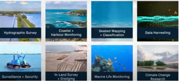
Key Applications (Seafloor Mapping Services)
Our services are trusted across multiple sectors for projects such as:
-
Port and harbour planning and maintenance
-
Subsea cable and pipeline routing
-
Shoreline erosion and sediment transport studies
-
River channel and floodplain mapping
-
Reservoir sedimentation and capacity analysis
-
Bridge scour inspections and foundation planning
-
Coastal restoration and habitat monitoring
-
Stormwater outfall and intake site assessments
-
Dredging pre-surveys and post-surveys
-
Environmental impact assessments (EIAs)
Advanced Tools & Technologies (Seafloor Mapping Services)
Ven‑Tech Subsea uses state-of-the-art equipment for both shallow and deep-water mapping, including:
-
Kongsberg and Blueprint multibeam sonar systems
-
Deep Trekker ROVs equipped with HD cameras and sonar
-
Aerial drones with RTK/PPK photogrammetry sensors
-
Side-scan sonar for object detection and bottom classification
-
Survey-grade GNSS RTK receivers for ground control and geolocation
-
Portable tide gauges and current meters for real-time correction
This multimodal approach ensures redundancy, accuracy, and completeness, even in turbid, low-visibility, or high-energy environments.
Integrated Data Analysis and Long-Term Monitoring for Seafloor Mapping Services
Ven-Tech Subsea’s Seafloor Mapping Services go beyond simple data collection — we deliver intelligence you can act on. Our integrated processing and analytics workflow combines sonar, LiDAR, and photogrammetry datasets into unified digital terrain models that help engineers and decision-makers visualize, measure, and predict underwater change with precision. Using industry-standard software such as Hypack, Qimera, and ArcGIS, our specialists perform advanced post-processing to remove noise, correct tidal offsets, and generate hydrodynamically consistent surfaces.
For clients who require ongoing monitoring or asset lifecycle support, we design repeatable survey frameworks that track year-over-year changes in sediment buildup, scour, or erosion. This proactive approach reduces risk to infrastructure, ensures regulatory compliance, and provides defensible datasets for environmental assessments and stakeholder reporting.
Our proprietary ATHENA system provides automated QA/QC checks, metadata tagging, and anomaly detection to identify deviations in bathymetry or structure geometry. When combined with machine learning trend analysis, these tools help forecast potential hazards or maintenance needs long before they become critical.
Ven-Tech Subsea’s mapping teams work closely with environmental consultants, civil engineers, and municipal planners to align each project with IHO, CHS, and CSA Z275 guidelines. Whether it’s validating dredge volumes, planning intake screens, or mapping submerged utilities, our deliverables provide a clear, certified foundation for confident design and construction.
By pairing high-resolution data with real-time field communication, Ven-Tech Subsea ensures every seafloor mapping mission meets client specifications on safety, precision, and sustainability — setting a new benchmark for hydrographic excellence in Canada and beyond.
Certified and Compliant Operations
All work is conducted in accordance with:
-
✅ CSA Z275.1 and Z275.4 Commercial Diving and ROV standards
-
✅ ISNetworld, Avetta, Cognibox, Alcumus CSA certified
-
✅ BCCSA COR Certified
-
✅ WorkSafeBC, WCB Alberta, and WSIB Ontario compliant
-
✅ Environmental compliance protocols for aquatic ecosystems
To learn more about the CSA diving and underwater survey standards we follow, you can review the official CSA Z275.1 Standard (external link).
Our integrated safety management system, ATHENA, ensures that all mapping operations include hazard mitigation, crew training, equipment calibration records, and full QA/QC documentation.
Deliverables You Can Build On
We provide survey deliverables that are tailored to the needs of engineers, planners, and environmental consultants:
-
🗺️ Seamless topo-bathy terrain models (TINs, DEMs)
-
📍 Georeferenced point clouds and vector contours
-
🧾 Shoreline change analysis and erosion risk models
-
📸 Orthomosaics and UAV photogrammetry datasets
-
📑 Detailed QA/QC reporting and compliance logs
-
🧠 AI-enhanced defect tagging and anomaly detection via ATHENA
-
🧰 AutoCAD (.dwg), ESRI (.shp), XYZ, LAS/LAZ, and PDF formats
We can also deliver your dataset via cloud-hosted 3D viewers for stakeholder access, or as part of a digital twin asset database.
Benefits of Working with Ven‑Tech Subsea for Seafloor Mapping Services
-
✔ One-Stop Data Collection – We handle above, below, and shoreline terrain in one contract
-
✔ Full Compliance – Adheres to CSA, COR, and all provincial safety codes
-
✔ Scalable Deployment – UAVs, sonar vessels, and portable ROVs mean we can map any site
-
✔ National Reach – We operate in Western Canada and Texas, with permits and insurance in place
-
✔ Specialized Expertise – Experts in shallow-water, high-resolution mapping environments
-
✔ Trusted by Industry – Work completed for Enbridge, District of Mackenzie, BC Hydro, and more
Serving Canada & the U.S.
Our teams are ready to mobilize across:
-
British Columbia – Interior lakes, Lower Mainland shorelines, coastal intakes
-
Alberta & Saskatchewan – Reservoir and river surveys, infrastructure planning
-
Nunavut & NWT – Northern community shoreline risk mapping, subsistence zone protection
-
Texas (U.S.) – Coastal erosion surveys, offshore platform approach surveys, pipeline corridor mapping
Overview: Integrated Seafloor Mapping Services and Coastal Zones
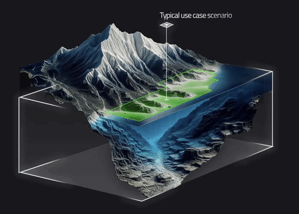
Ven-Tech Subsea delivers Integrated Seafloor Mapping Services that combine hydrographic science, remote sensing, and advanced robotics to produce a complete understanding of underwater and coastal environments. Our multidisciplinary mapping programs bridge the gap between the seafloor, shoreline, and shallow-water transition zones, enabling engineers and environmental planners to make data-driven decisions backed by precision measurements.
Using a combination of multibeam sonar, aerial LiDAR, ROV-mounted sensors, and RTK-corrected GNSS data, our mapping workflows produce unified digital terrain models (DTMs) of both subaqueous and terrestrial areas. This integration is vital for projects such as coastal infrastructure design, erosion monitoring, dredging verification, and marine habitat assessment—where accuracy at the water–land boundary is critical.
Our team of hydrographic surveyors, commercial divers, and GIS analysts conduct comprehensive Seafloor Mapping Services throughout Western Canada, from BC’s coastal harbors and river estuaries to Saskatchewan’s inland reservoirs and Alberta’s energy corridors. We also operate in the U.S. Pacific Northwest, supporting engineering and environmental projects that depend on accurate underwater elevation data and seabed classification.
Data Integration and Coastal Zone Mapping
Ven-Tech Subsea’s coastal zone mapping methodology merges sonar bathymetry with UAV and LiDAR topography, producing a seamless “topo-bathy” dataset that eliminates gaps in traditional surveys. This data is processed using Hypack, Qimera, and ArcGIS Pro, ensuring geospatial accuracy, smooth surface continuity, and full metadata traceability for regulatory compliance.
Our mapping programs capture:
-
Seafloor morphology and slope gradients
-
Sediment type and benthic composition
-
Intertidal elevations and shoreline features
-
Submerged structure geometry (piers, pipelines, intakes)
-
Tidal fluctuation and dynamic shoreline migration
This integrated approach allows Ven-Tech Subsea to deliver Seafloor Mapping Services that are compatible with BIM and Civil 3D environments, giving engineering teams direct import options for design and modeling.
Coastal Engineering and Environmental Applications
Our Seafloor and Coastal Mapping Services support a range of real-world applications:
-
Shoreline Erosion and Coastal Resilience Projects – Identifying critical erosion zones and informing restoration designs.
-
Floodplain and Storm Surge Modeling – Providing precise elevation baselines for risk mitigation.
-
Port and Harbour Development – Mapping dredge footprints and sediment transport patterns.
-
Subsea Utility Planning – Routing pipelines, cables, and conduits along safe and stable corridors.
-
Environmental Baseline and Impact Studies – Supporting fisheries management, aquatic vegetation mapping, and benthic habitat classification.
Each deliverable includes 3D bathymetric surfaces, contour shapefiles, georeferenced mosaics, and quality assurance reports verified by our ATHENA AI Quality Control System, ensuring that every dataset meets CSA and Canadian Hydrographic Service (CHS) accuracy standards.
Why Clients Choose Ven-Tech Subsea
Ven-Tech Subsea stands apart through our ability to combine hydrographic mapping, aerial photogrammetry, and diver-verified data under a single contract—streamlining communication and reducing project costs. With full COR, ISNetworld, Avetta, and Cognibox certifications, we operate safely in regulated and sensitive marine environments.
Our commitment to innovation, paired with CSA Z275-certified personnel, allows us to deliver repeatable, defensible mapping results that withstand engineering review, environmental audit, and long-term asset management cycles. Whether you need to evaluate a harbor expansion, validate dredging volumes, or map critical shorelines for infrastructure design, Ven-Tech Subsea provides the technology, expertise, and reliability to bring clarity beneath the surface.
For consultation or pricing on Integrated Seafloor Mapping Services and Coastal Zone Surveys, contact our mapping specialists today at https://ven-techsubsea.ca.
Contact Ven‑Tech Subsea Today
If you’re planning a shoreline restoration, underwater installation, or coastal infrastructure project, our Seafloor and Shoreline Mapping services are ready to deliver the critical data you need—safely, efficiently, and accurately.
📞 Call us: 604‑230‑3022
📧 Email: info@ven-techsubsea.ca
🌐 Web: https://ven-techsubsea.ca
Let us build the map your next project depends on.