Geographic Survey Services – Precision Data Capture with Advanced USV & ROV Technology
Ven‑Tech Subsea delivers elite Geographic Survey Services across North America, providing comprehensive hydrographic, geophysical, and environmental data solutions powered by our fleet of USV (Unmanned Surface Vehicles), ROVs (Remotely Operated Vehicles), and integrated geospatial sensors. Tailored for municipalities, engineering firms, pipeline operators, marine contractors, and environmental consultants, our services are rooted in precision, safety, and regulatory compliance — including CSA-backed protocols from CSA Group.
What Are Geographic Survey Services?
Geographic Survey Services encompass advanced data collection methods to map and understand underwater and surface environments. Leveraging unmanned platforms and specialized sensors, Ven‑Tech Subsea captures bathymetry, seafloor composition, pipeline alignment, habitat integrity, and more. Our methods are ideal where depth, access, or safety concerns make traditional boats or manual surveying impractical.
Why Choose Our Geographic Survey Services?
-
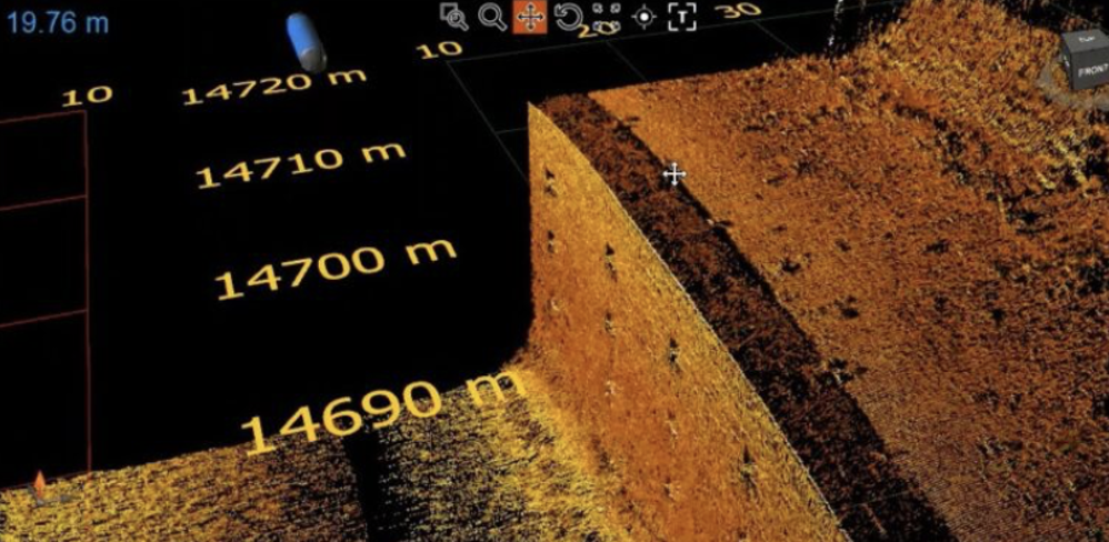
Exact-precision mapping using multibeam echosounders, side-scan sonar, and single-beam systems
-
Sediment and subsurface insights with sub-bottom profilers
-
Water column analysis via SVPs, ADCPs, and environmental sensors
-
Laser-grade asset and obstacle documentation through onboard LiDAR
-
Centimeter-accurate positioning using RTK GNSS and integrated inertial navigation systems
-
Efficient, safe operations via unmanned platforms without personnel risk
All data is processed into engineer-ready formats, GIS layers, CAD plans, and 3D models—plus deliverables include aerial/satellite imagery overlays where requested.
Our Workflow
1. Pre-Survey Planning
We define survey boundaries, positional accuracy targets, sensor configurations, and processing expectations in consultation with your team. A detailed plan is produced and connected to your compliance requirements, including CSA standards and municipal guidelines.
2. Mobilization & Permitting
Our versatile USV systems and ROV trailers deploy locally or domestically with required permits, insurance, and marine notifications. We handle site coordination end-to-end.
3. Field Deployment
USVs autonomously navigate survey grids, collecting synchronized multibeam, side-scan, SVP, ADCP, GNSS, and LiDAR data. Our ROVs inspect anomalies or confined structures identified during the USV pass.
4. Data Processing & QA
Land-based teams perform GPS tidal corrections, sound velocity adjustments, sonar mosaic creation, point cloud generation, and deliver geospatial datasets to exact specifications.
5. Final Reporting & Delivery
We provide detailed reports, GIS/CAD files, 3D models, and recommendations. All documentation includes metadata logs and QA/QC traceability for regulatory compliance and project records.
Platforms & Sensor Packages
USV Fleet
-
Compact autonomous vessels equipped with multibeam + side-scan sonar, RTK, IMU, LiDAR, water-sampling probes, and sub-bottom profilers
-
Capable of surveying shallow rivers, ports, reservoirs, dams, and oil/pipeline corridors
-
Real-time mission control and live data feeds
ROV Systems
-
Deep Trekker-class units with HD/4K cameras, laser scaling, conductivity sensors
-
Deployed in confined or hazardous areas for verification and inspection
Sensor Suite
-
Multibeam echosounders: full bathymetric mapping
-
Side-scan sonar: detailed visual mapping of soft sediments or debris
-
Sub-bottom profilers: up to several meters penetration below seabed
-
Sound velocity profilers: water column corrections
-
RTK + GNSS: centimeter-level positional accuracy
-
IMU/INS: stability in currents
-
Water-quality sensors: depth, temperature, conductivity, turbidity
-
LiDAR scanners: overhead asset detection and modeling
Applications of Geographic Survey Services
-
Pipeline & cable route verification, ensuring safe terrain and positional accuracy
-
Bathymetric surveys before/after dredging, construction, or sediment study
-
Outfall & intake structure mapping for permit compliance
-
Environmental monitoring of habitats, erosion, and marine life zones
-
Structural inspections under bridges, docks, dams, and locks
-
Flood / urban planning via combined GIS + underwater terrain models
Industries & Clients
Our Geographic Survey Services benefit:
-
Municipal and regional governments
-
Engineering firms and design-build contractors
-
Oil/gas and energy developers
-
Marine constructors and port authorities
-
Environmental and habitat conservation bodies
-
First Nations and community utilities
-
Mining, pulp/paper, and utility licensors
Why Ven‑Tech Subsea Excels
-
Complete Platforms: USV + ROV + diver synergy in unified projects
-
Technical Precision: High-spec sensor integration and calibration
-
Quality Delivery: 7-day turnaround for most projects
-
Compliance-Ready: CSA, ISO, WorkSafe documentation included
-
Cost-Effective: Unmanned survey cuts operational and insurance costs
-
Safety-First: Remote operation avoids personnel risk in dangerous waters
Contact Us
Ready to leverage our Geographic Survey Services for your next project? Ven‑Tech Subsea is here to deliver unmatched precision and compliance. Reach out for quotes, tech demos, or site evaluations:
Certified under CSA standards via CSA Group