Bathymetric Mapping Services
Ven-Tech Subsea is proud to offer advanced Bathymetric Mapping Services across Canada and the Pacific Northwest, delivering precision seafloor and underwater terrain data using high-resolution sonar and unmanned surface vehicles (USVs). These services support a wide range of industries, including marine construction, environmental monitoring, infrastructure development, aquaculture, and offshore energy.
Our bathymetric mapping capabilities allow clients to understand subsurface conditions with clarity, precision, and confidence. Leveraging cutting-edge technologies such as multibeam sonar, single-beam sonar, side-scan sonar, GNSS positioning, and RTK-corrected data, Ven-Tech Subsea provides the most accurate and efficient underwater topographic models available in the market today.
Ven-Tech Subsea is a Canadian-based commercial diving and marine robotics company specializing in underwater construction, infrastructure inspections, and advanced survey solutions.
Since 2014, Ven-Tech Subsea has delivered trusted diving, ROV, and robotic inspection services across Western Canada and beyond. Our capabilities extend from confined space and potable water tank inspections to pipeline condition assessments, ROV-based inspections, Unmanned Surface Vehicle (USV) deployments, and comprehensive geographic and hydrographic surveys.
With a commitment to safety, precision, and innovation, we support municipalities, utilities, engineering firms, and industrial clients with solutions tailored to complex subsea environments. Whether above ground, below ground, or offshore, Ven-Tech Subsea ensures professional execution and high-quality results—every time.
What is Bathymetric Mapping?
Bathymetric mapping is the underwater equivalent of topographic mapping, used to measure the depth and shape of underwater surfaces. These surveys are critical for:
- Mapping reservoirs, rivers, lakes, oceans, and estuaries
- Navigational safety and hazard identification
- Dredging and sediment transport modeling
- Environmental studies and baseline mapping
- Infrastructure siting and marine construction planning
Core Technologies We Use
Ven-Tech Subsea integrates a comprehensive suite of marine survey technologies to deliver complete bathymetric datasets:
- Multibeam Sonar Systems (e.g., Norbit, R2Sonic): For full swath seafloor coverage and 3D terrain generation
- Single-Beam Echo Sounders: For quick, cost-effective depth readings in smaller or shallow water bodies
- Side-Scan Sonar: For identifying objects, seabed composition, and submerged structures
- Differential GNSS & RTK Corrections: To ensure centimeter-level positional accuracy
- USVs (Unmanned Surface Vehicles): For safe and efficient mapping in sensitive, shallow, or hazardous environments
These tools provide a rich dataset ideal for post-processing into digital elevation models (DEMs), nautical charts, and hydrographic reports.
Applications of Bathymetric Mapping Services
Ven-Tech Subsea’s bathymetric surveys are tailored to meet the demands of a variety of commercial, industrial, and governmental clients:
- Hydroelectric & Dams: Monitor sedimentation, erosion, and dam health
- Port Authorities & Navigation: Chart safe shipping routes and detect underwater hazards
- Pipeline & Cable Routing: Identify optimal routes for buried or laid subsea infrastructure
- Environmental Monitoring: Assess habitat degradation and waterway morphology
- Construction Support: Support pile driving, dredging, cofferdam installation, and caisson placement
- Aquaculture: Determine site suitability and monitor benthic conditions
Advantages of Choosing Ven-Tech Subsea
- Unmanned & Safe: Our USV systems allow for autonomous mapping in dangerous or confined areas, reducing risk to personnel.
- High Accuracy: Our surveys meet or exceed hydrographic survey standards such as those set by the Canadian Hydrographic Service.
- Rapid Deployment: Based in British Columbia, with teams across Alberta, Saskatchewan, and Vancouver Island, we respond quickly to client needs throughout Western Canada.
- CSA & WorkSafeBC Compliant: Our operations meet strict Canadian safety and environmental standards. Learn more about CSA Standards here.
- Client Portal: Every project includes access to downloadable reports, maps, GIS files, and raw data through our secure digital platform.
Deliverables
All bathymetric mapping projects come with a comprehensive set of deliverables, customized to each client’s objectives:
- Digital Terrain Models (DTMs)
- 2D and 3D bathymetric charts
- Cross-sectional profiles
- GeoTIFFs and ASCII grid files for GIS integration
- Volume calculations for dredging or sediment estimates
- High-resolution side-scan mosaics
- Detailed PDF reports with embedded visuals and data summaries
Areas We Serve
Ven-Tech Subsea provides Bathymetric Mapping Services throughout:
- British Columbia
- Alberta
- Saskatchewan
- Northwest Territories
- Yukon
- Nunavut
- Pacific Northwest USA (select regions)
For more information or to request a quote, visit our contact page.
Advanced Bathymetric Mapping Services Across Canada
Ven-Tech Subsea continues to set the benchmark for precision Bathymetric Mapping Services in Canada, combining advanced sonar, robotics, and data analytics to deliver high-resolution mapping results for coastal, inland, and offshore environments. Our multidisciplinary approach integrates hydrography, engineering, and environmental science, ensuring that every survey is accurate, safe, and tailored to the client’s project goals.
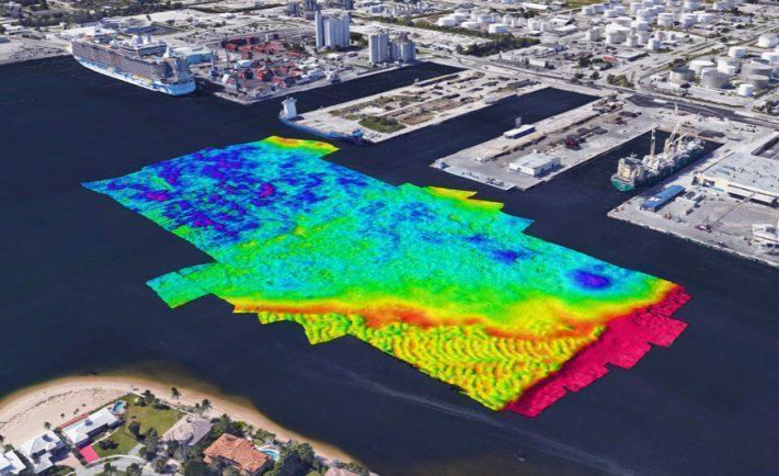
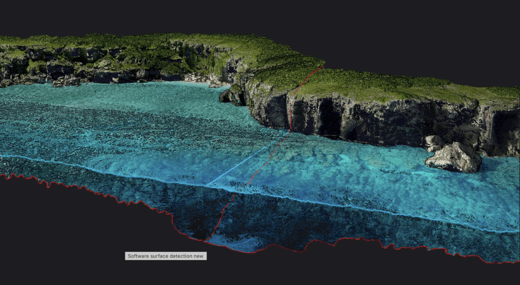
Our experienced surveyors and technicians use purpose-built hydrographic vessels and USV platforms to conduct both Bathymetric Mapping Services and Hydrographic Survey Services across rivers, reservoirs, harbors, and coastal zones. By integrating multibeam sonar and RTK GPS systems, Ven-Tech Subsea generates dense 3D point clouds and digital terrain models (DTMs) that capture every contour of the underwater environment with unmatched precision.
Industry-Leading Hydrographic and Bathymetric Expertise
As one of Canada’s most innovative underwater contractors, Ven-Tech Subsea specializes in a variety of Bathymetric Mapping Services applications including sedimentation analysis, dredging support, and infrastructure monitoring. Our surveys meet or exceed the standards set by the Canadian Hydrographic Service (CHS) and IHO S-44 guidelines for accuracy and resolution.
Using powerful data acquisition and post-processing software, we create seamless topographic and bathymetric datasets that are compatible with major GIS and CAD platforms. This makes it easy for engineers, environmental scientists, and marine planners to interpret, visualize, and act on the data we deliver.
Ven-Tech Subsea’s Bathymetric Mapping team employs a fleet of Unmanned Surface Vehicles (USVs) designed for precision mapping in shallow or restricted-access areas. These compact autonomous vessels are equipped with survey-grade multibeam echosounders, IMUs, and RTK antennas, enabling precise Bathymetric Mapping Services in locations where traditional boats cannot safely operate.
Integrated Data and 3D Modelling
Our Bathymetric Mapping Services are enhanced by our in-house AI data analysis system, ATHENA, which ensures optimal quality control and consistency across large datasets. ATHENA automatically validates sonar returns, flags anomalies, and produces quality metrics that are reviewed by our hydrographic specialists.
Deliverables include:
-
Digital Elevation Models (DEMs) with centimeter-level vertical accuracy
-
3D point clouds and cross-section visualizations
-
Volume change assessments for dredging or sediment removal projects
-
Georeferenced orthomosaics for integration with environmental and engineering workflows
By combining Bathymetric Mapping Services with side-scan sonar and sub-bottom profiling, Ven-Tech Subsea provides a full understanding of both the seafloor surface and the underlying structure. This comprehensive data enables clients to assess erosion rates, infrastructure conditions, and habitat distribution with confidence.
Applications of Bathymetric Mapping Services
Ven-Tech Subsea’s expertise supports a diverse range of sectors that rely on underwater data accuracy:
-
Municipal and Utility Infrastructure – Reservoir depth profiling, intake condition assessments, and potable water system mapping.
-
Environmental Engineering – Sediment transport modeling, aquatic habitat mapping, and erosion monitoring.
-
Marine Construction – Dredge verification, caisson positioning, and cofferdam foundation analysis.
-
Energy and Resource Development – Pipeline routing, cable corridor design, and tailings pond surveys.
-
Hydroelectric Facilities – Dam basin mapping, sediment accumulation tracking, and turbine intake monitoring.
-
Ports and Harbors – Navigational charting and berth condition analysis.
Every bathymetric dataset is georeferenced, verified, and validated to support regulatory submissions, engineering design, and environmental management plans.
Commitment to Quality, Safety, and Compliance
Ven-Tech Subsea’s Bathymetric Mapping Services are carried out under strict adherence to CSA and WorkSafeBC regulations for marine and diving operations. All personnel are trained in CSA Z275.2 and Z275.4 Commercial Diving Standards, and our USV and vessel-based surveys follow Transport Canada marine safety requirements.
We also maintain:
-
ISNetworld, Avetta, Cognibox, and COR certifications
-
Full $5 million Commercial Liability Insurance coverage
-
Documented Quality Assurance (QA/QC) procedures verified under the ATHENA data management system
Our proven commitment to safety and precision ensures that each bathymetric survey exceeds the expectations of our clients in both accuracy and reliability.
Why Choose Ven-Tech Subsea for Bathymetric Mapping Services
✅ Unmatched Accuracy: Our surveys achieve centimeter-grade precision through RTK GNSS and motion-compensated multibeam systems.
✅ Comprehensive Deliverables: We provide complete geospatial datasets, reports, and 3D visualizations.
✅ Environmental Responsibility: Our methods minimize disturbance in sensitive ecosystems, ensuring compliance with federal and provincial regulations.
✅ Proven Experience: Over a decade of operational excellence in hydrography, commercial diving, and underwater construction.
✅ Rapid Mobilization: Strategically located teams across British Columbia, Alberta, Saskatchewan, and the Pacific Northwest for quick deployment.
Service Coverage
Ven-Tech Subsea provides professional Bathymetric Mapping Services in:
-
British Columbia (coastal, interior, and northern regions)
-
Alberta (reservoirs and industrial systems)
-
Saskatchewan and Manitoba (hydroelectric and utility sectors)
-
Nunavut and the Northwest Territories (remote and northern mapping)
-
Pacific Northwest United States
Our mission is to make accurate bathymetric data accessible, actionable, and efficient — helping clients plan, construct, and maintain their infrastructure with confidence.