Hydrographic Survey Services – Advanced Marine Mapping with USV & ROV Precision
Ven‑Tech Subsea provides industry-leading Hydrographic Survey Services across Canada, specializing in precision underwater mapping, bathymetry, and marine data acquisition for infrastructure, utility, energy, and environmental applications. Using state-of-the-art USV (Unmanned Surface Vehicle) and ROV (Remotely Operated Vehicle) platforms, we deliver comprehensive and cost-effective solutions that meet CSA and WorkSafeBC standards for safety, performance, and reporting accuracy.
Whether you’re managing port infrastructure, planning a pipeline route, monitoring sediment buildup, or conducting a pre-construction assessment, our Hydrographic Survey Services are designed to deliver high-resolution data, fast turnaround, and actionable insights.
What Are Hydrographic Survey Services?
Hydrographic Survey Services involve the systematic measurement and description of physical features beneath bodies of water. These services support safe navigation, marine construction, environmental monitoring, and asset inspection by using specialized sonar, positioning, and data acquisition tools to map underwater environments with extreme accuracy.
Ven‑Tech Subsea’s services are performed using a fleet of autonomous USVs and observation-class ROVs equipped with multibeam echo sounders, side-scan sonar, LiDAR, RTK GNSS, and sub-bottom profilers to create detailed charts, models, and spatial datasets.
Why Choose Ven‑Tech Subsea for Hydrographic Survey Services?
-
Fully autonomous survey coverage using electric and diesel-hybrid USVs
-
CSA-compliant documentation and reporting in accordance with CSA Group and regional marine regulations
-
High-resolution data capture using synchronized sonar, positioning, and velocity correction systems
-
Fast deployment across Western Canada, with projects completed in 5–10 business days
-
Integrated capabilities with ROV, diver inspections, and post-survey analysis
With over a decade of experience supporting marine, pipeline, and environmental projects, we ensure that every Hydrographic Survey Services project delivers the detail and reliability our clients demand.
Our Technology & Capabilities
USV Survey Systems
Ven‑Tech’s USVs are custom-fitted for rapid hydrographic mapping. Each unit is equipped with:
-
Multibeam echo sounders for high-precision bathymetry
-
Side-scan sonar for seafloor imagery and obstacle detection
-
Sub-bottom profilers for layering beneath sediment beds
-
LiDAR for above-surface modeling of piers, breakwaters, and shoreline assets
-
RTK GNSS + Inertial Navigation Systems for accurate positioning
-
SVPs + ADCPs for sound velocity correction and current profiling
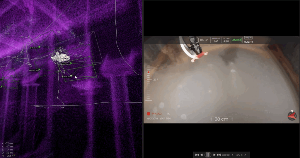
ROV Integration
In support of detailed inspections, ROVs equipped with 4K video, sonar, and laser scalers are deployed to verify anomalies, inspect intake/outfall structures, or work within confined or low-visibility conditions.
Hydrographic Survey Services Applications
Our Hydrographic Survey Services are tailored for diverse environments, including:
-
Ports, harbours & shipping lanes
-
Hydroelectric dams & reservoirs
-
Stormwater outfalls & marine intakes
-
Pipeline & subsea cable corridors
-
Dredging operations & pre/post surveys
-
Wetland & coastal zone assessments
-
Mining tailings ponds & settling basins
-
Bridge, dock, and piling inspections
We provide deliverables in CAD, GIS, 3D mesh, point cloud, or engineering-ready formats, including georeferenced models compatible with ESRI and AutoCAD platforms.
The Ven‑Tech Process
1. Client Consultation & Planning
We work closely with engineering teams, municipalities, and project managers to define scope, access, coverage zones, target resolutions, and regulatory requirements.
2. Mobilization & Safety Compliance
Each job includes hazard assessments, NOP filings (if applicable), environmental mitigation plans, and all insurance and WorkSafeBC clearances.
3. Field Execution
Our team deploys USVs and ROVs to collect data according to pre-defined gridlines. Our vessels operate autonomously, avoiding risk to personnel and reducing vessel wake in sensitive environments.
4. Post-Processing & Data QA
Hydrographic data is processed using industry-standard software with corrections for velocity, tidal fluctuations, and georeferencing. All results undergo QA/QC review and multi-format export.
5. Final Reporting & Recommendations
Clients receive a comprehensive digital report including raw and processed data, visual models, GIS files, bathymetric maps, and written observations.
Who We Serve
Our Hydrographic Survey Services support a wide range of clients across sectors:
-
Municipal & regional governments
-
Marine engineering & construction firms
-
Oil & gas pipeline operators
-
Environmental and conservation consultants
-
Hydro dam operators & utilities
-
Mining & industrial sites with water-based assets
-
First Nations & Indigenous resource partners
Why Our Hydrographic Survey Services Stand Out
-
Multimodal delivery: Combine USV, ROV, and diver inspections under one contractor
-
Regulatory documentation: CSA standard compliance, environmental protection protocols
-
High-resolution output: Deliverables suitable for engineering design or permitting
-
Cost-effective solutions: Unmanned platforms reduce labour, risk, and fuel costs
-
Field-tested in Canada: Proven performance in BC, Alberta, and Saskatchewan environments
Our team includes hydrographic specialists, marine biologists, commercial divers, and data analysts—ensuring your survey is executed by experts who understand field challenges and engineering deliverables.
Get Started with Hydrographic Survey Services
Whether you’re developing a port, restoring a watershed, or managing subsurface infrastructure, Ven‑Tech Subsea’s Hydrographic Survey Services provide the clarity and confidence you need to make informed decisions.
Contact us today to schedule a site assessment, receive a quote, or learn more about our integrated USV/ROV systems:
👉 Click here to contact Ven‑Tech Subsea
Certified. Compliant. Precise. That’s the Ven‑Tech standard.