Bathymetric LiDAR Mapping Services
Overview: Cutting-Edge Aerial Hydrography for Shallow Water Mapping
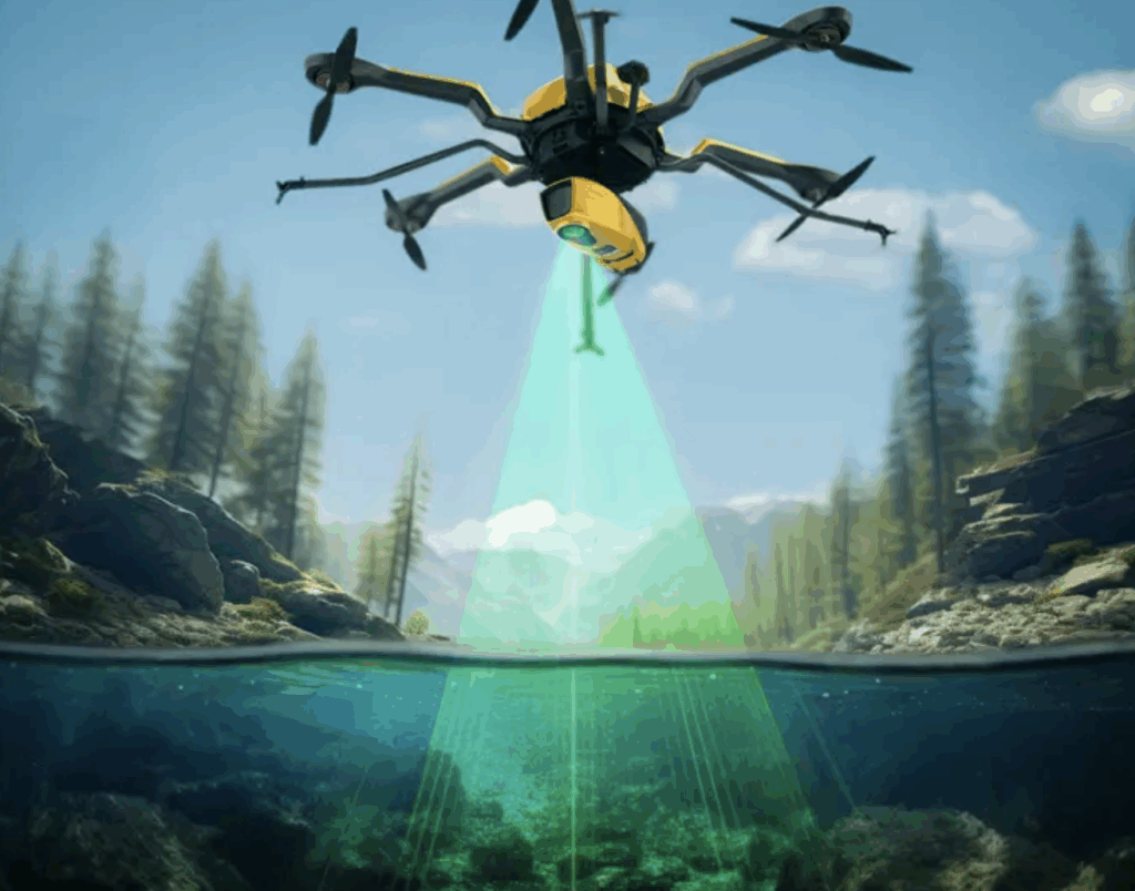
Ven-Tech Subsea proudly offers Bathymetric LiDAR Mapping services, providing a powerful, non-invasive way to map underwater and coastal environments with unmatched efficiency and accuracy. Our airborne systems use dual-wavelength LiDAR technology to capture high-resolution data of both land and shallow water areas—ideal for lakes, rivers, reservoirs, estuaries, wetlands, and nearshore coastal zones.
Bathymetric LiDAR bridges the gap between land-based topographic surveys and traditional sonar-based hydrography by using aircraft-mounted lasers to penetrate water and measure depth, without needing to deploy boats or divers. This method is ideal for areas that are remote, dangerous, environmentally sensitive, or where rapid large-scale data collection is needed.
Whether you’re planning a coastal engineering project, evaluating sediment transport, or mapping erosion zones, our aerial LiDAR bathymetry delivers a seamless, cost-effective solution that integrates effortlessly into CAD, GIS, and BIM workflows.
What is Bathymetric LiDAR Mapping Services?
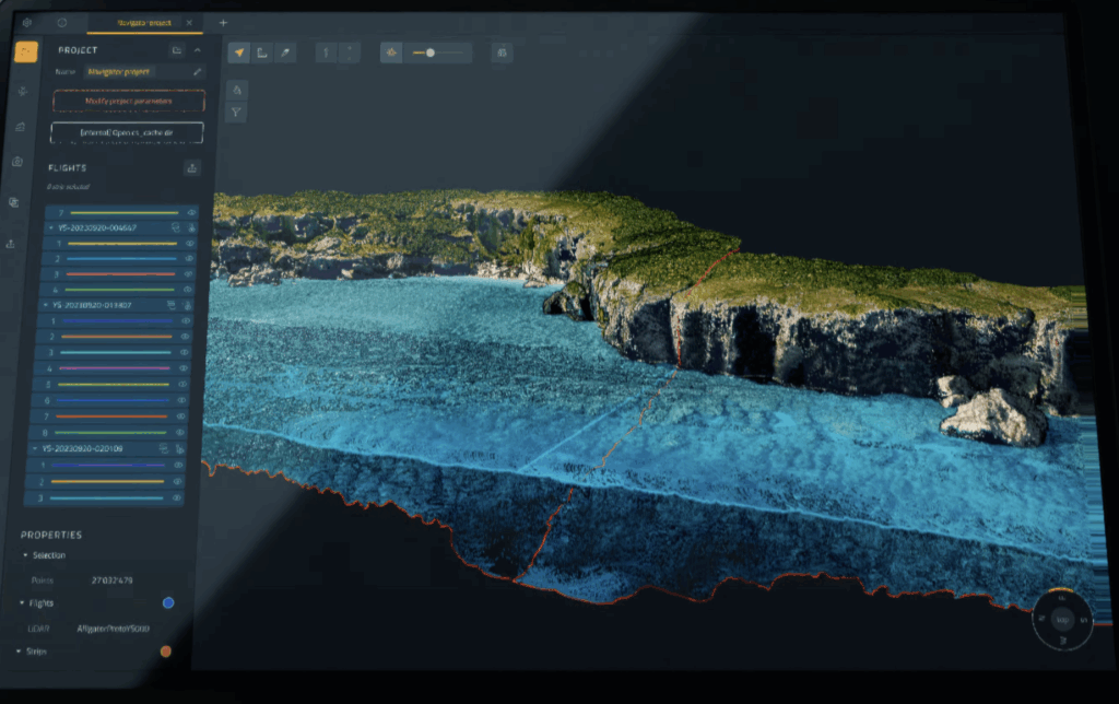
Bathymetric LiDAR (Light Detection and Ranging) is an active remote sensing technology that uses two lasers: a green laser (532 nm) that penetrates water to measure depth, and a near-infrared laser (1064 nm) for land surface mapping. These lasers are deployed from a fixed-wing aircraft or UAV (drone), along with an inertial measurement unit (IMU) and high-accuracy GNSS receiver to precisely geolocate every data point.
The green laser detects the difference between the water surface and the bottom, allowing us to generate high-resolution 3D models of underwater terrain (bathymetry). The result is a detailed, accurate, and seamless digital elevation model (DEM) of the land-water interface.
Bathymetric LiDAR is highly effective in depths of up to 50 meters, depending on water clarity, and excels in mapping transitional zones, such as where rivers meet the sea, lakes connect to wetlands, or shorelines change rapidly due to erosion or development.
Applications of Bathymetric LiDAR Mapping Services
Ven-Tech Subsea offers bathymetric LiDAR mapping services tailored for government, industrial, environmental, and infrastructure clients across Canada and the U.S. Key applications include:
-
Shoreline and Coastal Zone Mapping
-
Lakebed and Riverbed Surveys
-
Reservoir and Dam Safety Assessments
-
Pre- and Post-Dredging Surveys
-
Erosion Monitoring and Sediment Transport Studies
-
Floodplain Modeling and Risk Mitigation
-
Pipeline, Cable, and Bridge Route Planning
-
Environmental Impact Assessments (EIAs)
-
Delta, Estuary, and Wetland Mapping
-
Hydroelectric Infrastructure and Intake Zone Mapping
This service supports a wide range of clients in sectors including municipal engineering, energy, utilities, transportation, mining, ports, and marine construction.
Integrating Bathymetric LiDAR with Subsurface and ROV Technologies
What makes Ven-Tech Subsea unique among LiDAR mapping providers is our ability to integrate bathymetric LiDAR data with ROV, sonar, and geophysical datasets to deliver a complete view of underwater environments. By combining top-down aerial LiDAR coverage with high-resolution subsurface imaging, we can model not just the shape of the lakebed or reservoir, but also the condition of submerged assets such as pipelines, intake structures, bridge footings, and dam faces.
This hybrid approach allows engineers, hydrologists, and environmental planners to visualize and quantify changes in sedimentation, erosion, and aquatic habitat in unprecedented detail. Our ATHENA AI platform further enhances this process by performing intelligent data fusion, error correction, and quality scoring—ensuring every project meets the most demanding accuracy standards.
In addition, Ven-Tech Subsea’s bathymetric LiDAR services can be deployed as part of a long-term monitoring program, enabling clients to detect environmental or structural changes year over year. From hydroelectric reservoirs to delta restoration projects, this capability supports proactive maintenance, compliance with regulatory requirements, and improved asset management decisions.
With our integrated technology stack and commitment to precision, Ven-Tech Subsea continues to redefine what’s possible in modern hydrographic and coastal mapping.
Why Choose Ven-Tech Subsea for Bathymetric LiDAR Mapping Services?
At Ven-Tech Subsea, we combine deep technical expertise, strict regulatory compliance, and operational flexibility to deliver best-in-class results for every project. Our clients choose us for:
✅ Multi-disciplinary Integration: We seamlessly integrate LiDAR with sonar, ROV, diver, and drone survey data
✅ Rapid Deployment: Aerial data collection minimizes site access delays and completes large areas in days
✅ Minimal Impact: No vessels or divers needed—ideal for remote, protected, or hazardous sites
✅ Regulatory Confidence: Deliverables conform to IHO S-44, CHS, USACE, and NOAA standards
✅ ATHENA AI Integration: Proprietary data QA/QC and reporting system enhances accuracy and client reporting
All flight operations are conducted by Transport Canada/FAA-certified operators, using survey-grade LiDAR hardware and post-processing software. Our data is ready for use in CAD, GIS, Civil 3D, and other engineering environments.
Advanced Capabilities in Bathymetric LiDAR Mapping Services
Ven-Tech Subsea continues to lead Canada’s hydrographic and environmental mapping sector with its advanced Bathymetric LiDAR Mapping Services. Designed for high-resolution data capture across lakes, rivers, estuaries, and coastlines, our solutions provide precise topographic and bathymetric information in a single seamless dataset. Whether supporting environmental studies, port development, or dam rehabilitation, we deliver dependable aerial hydrography that empowers engineers, planners, and environmental scientists to make data-driven decisions.
What sets our Bathymetric LiDAR Mapping Services apart is the integration of real-time GNSS, IMU, and dual-laser technology to ensure absolute positional accuracy. Our systems are capable of penetrating turbid or shallow waters where sonar cannot operate effectively, providing consistent results even in complex coastal terrain. Every mission is carefully planned around solar angle, turbidity, and weather windows to guarantee maximum water-bottom return quality.
Ven-Tech Subsea’s Bathymetric LiDAR Mapping Services can also be merged with multibeam sonar, photogrammetry, and sub-bottom profiling to produce a complete environmental dataset. By combining aerial and underwater perspectives, we help clients evaluate sedimentation, scour, erosion, and ecological change over time. Our workflows are fully compatible with ESRI ArcGIS, AutoCAD Civil 3D, Global Mapper, and Bentley platforms—ensuring smooth integration into engineering and environmental models.
In addition, all bathymetric data is processed through ATHENA AI, Ven-Tech Subsea’s proprietary analytics and quality-control platform. ATHENA automatically flags anomalies, calibrates cross-track data, and validates vertical accuracy against benchmarked survey control. This advanced QA/QC process ensures that every deliverable from our Bathymetric LiDAR Mapping Services meets or exceeds IHO S-44 and CHS accuracy standards.
Our flight operations are conducted by Transport Canada-certified crews using survey-grade LiDAR systems, allowing rapid deployment across British Columbia, Alberta, Saskatchewan, and northern regions where conventional surveys are impractical. With over a decade of experience in commercial diving, ROV inspection, and remote hydrography, Ven-Tech Subsea offers a unique combination of subsurface expertise and aerial precision that few mapping companies can match.
For large-scale shoreline mapping, dam safety surveys, or infrastructure planning, Ven-Tech Subsea’s Bathymetric LiDAR Mapping Services provide the clarity, coverage, and confidence your project demands—delivered safely, efficiently, and with full regulatory compliance across every environment.
Certifications and Compliance
Ven-Tech Subsea is certified and approved by the industry’s leading safety and quality platforms:
-
ISNetworld, Avetta, Cognibox, Alcumus CSA Star
-
BCCSA COR Certified
-
WorkSafeBC and WCB Compliant in All Provinces
-
$5,000,000 Commercial Liability Insurance
-
CSA Z275.1 & Z275.4 Diving and ROV Standards
-
IHO/CHS-compliant data acquisition and QC
We maintain a spotless safety record, detailed SOPs for data acquisition and risk mitigation, and offer project-specific Environmental and Safety Plans upon request.
Standard Deliverables
Our bathymetric LiDAR mapping packages typically include:
-
📍 Classified 3D Point Clouds (.las/.laz)
-
🌐 Digital Elevation Models (DEMs) and Terrain Models (DTMs)
-
🗺️ Topo-Bathymetric Contour Maps (AutoCAD, ESRI, MicroStation compatible)
-
📸 Orthorectified Aerial Imagery (RGB or Multispectral)
-
📑 Detailed Survey Report with QA/QC Methodology
-
💻 Optional 3D Viewer or Cloud-Based Delivery Portal
We also offer optional integration with multibeam sonar, side-scan sonar, photogrammetry, ROV video, and geophysical data for comprehensive seabed and sub-bottom profiling.
Service Coverage
Ven-Tech Subsea provides bathymetric LiDAR mapping services throughout:
-
British Columbia
-
Alberta
-
Saskatchewan
-
Manitoba
-
Ontario
-
Nunavut & Northwest Territories
-
Texas & Pacific Northwest (U.S. expansion)
Whether you’re mapping a glacial lake in the North, assessing sedimentation in a hydroelectric reservoir, or conducting a pre-construction survey in coastal Texas, we deliver fast, flexible, and scalable results tailored to your needs.
Contact Us Today for a Free Consultation
Ready to harness the power of airborne LiDAR for your next shoreline, reservoir, or river mapping project? Let Ven-Tech Subsea bring speed, precision, and safety to your workflow.
📧 Email: info@ven-techsubsea.ca
📞 Phone: 604-230-3022
🌐 Website: https://ven-techsubsea.ca