
Ven-Tech Subsea Inspections – The West Coast’s Leading Provider of ROV Photogrammetry Services
At Ven-Tech Subsea Inspections, we are pioneering ROV Photogrammetry Services, setting a new standard for underwater asset inspections, marine construction, and infrastructure integrity assessments. As the only company on the West Coast of Canada offering this advanced technology, we provide high-resolution 3D models that revolutionize the way underwater structures are inspected, documented, and maintained.
Our ROV Photogrammetry solutions deliver unparalleled accuracy, cost-efficiency, and safety, making traditional underwater inspections obsolete in many applications. Whether you need to assess reservoirs, pipelines, offshore structures, or submerged assets, our cutting-edge 3D imaging and digital twin technology provides the most detailed and reliable data available.
What is ROV Photogrammetry?
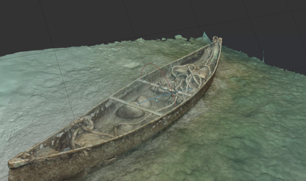
ROV Photogrammetry is a non-contact, high-precision imaging method that uses an ROV-mounted camera system to capture thousands of high-resolution images of underwater structures. These images are then processed using advanced 3D reconstruction software, creating a highly detailed, scaled, and georeferenced digital model of the submerged asset.
Key Benefits of ROV Photogrammetry:
✔ Unmatched 3D Accuracy – High-definition, real-world scale 3D models for precise measurements and analysis.
✔ Non-Destructive Testing (NDT) – Capture structural integrity data without physical contact.
✔ Cost-Effective & Time-Saving – Eliminates the need for extensive manual inspections and reduces costly downtime.
✔ Enhanced Safety – Reduces human exposure in hazardous underwater environments.
✔ Permanent Digital Records – Maintain historical 3D models for asset lifecycle monitoring.
✔ Remote Access & Analysis – Clients can review inspections from anywhere in the world via cloud-based reports.
Applications of ROV Photogrammetry Services
Our ROV Photogrammetry technology is applicable to a wide range of industries, providing unrivaled detail and accuracy for underwater infrastructure and marine assets.
➤ Marine & Offshore Infrastructure Inspections
• Port & Harbor Structures – Inspect seawalls, pilings, breakwaters, and mooring systems.
• Bridge Piers & Underwater Foundations – Monitor for cracks, scouring, and deterioration.
• Offshore Wind Turbines & Subsea Platforms – Assess corrosion, marine growth, and structural integrity.
➤ Municipal & Potable Water Reservoirs (AWWA C652-19 Compliant)
• Water Reservoir & Tank Inspections – Conduct fully compliant potable water inspections without draining the reservoir.
• Intake & Outfall System Assessments – Identify sediment buildup, blockages, and pipe degradation.
• Stormwater & Wastewater System Surveys – Monitor pipeline conditions, leaks, and defects.
➤ Oil & Gas Asset Integrity Surveys
• Subsea Pipelines & Risers – Detect leaks, corrosion, and mechanical failures.
• FPSOs & Underwater Storage Facilities – Ensure compliance with regulatory safety standards.
• Offshore Drilling Infrastructure – Analyze subsea wellheads and production systems.
➤ Environmental Monitoring & Marine Conservation
• Seafloor Mapping & Habitat Monitoring – Capture topographic data for environmental impact studies.
• Artificial Reef & Marine Growth Analysis – Track coral reef restoration and biodiversity.
• Fish Farm & Aquaculture Infrastructure Surveys – Inspect nets, cages, and mooring systems.
How Our ROV Photogrammetry Process Works
Our ROV Photogrammetry workflow ensures precise data collection and high-resolution 3D model generation tailored to each project’s requirements.
1️⃣ Site Assessment & Planning
• Define inspection goals and determine optimal imaging conditions.
• Identify lighting, water visibility, and object surface characteristics.
2️⃣ ROV Deployment & Data Capture
• Use Deep Trekker Revolution ROV with 4K high-resolution cameras for superior image acquisition.
• Capture thousands of overlapping images for full-coverage 3D modeling.
3️⃣ Data Processing & 3D Model Generation
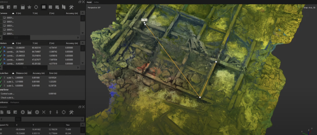
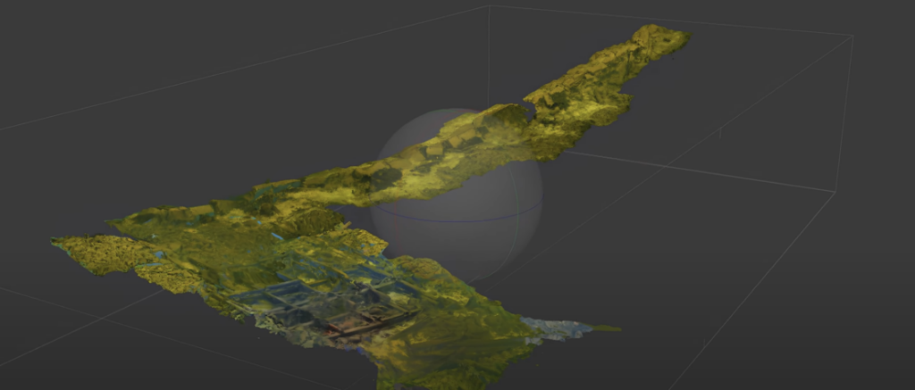
• Use advanced photogrammetry software to reconstruct accurate, georeferenced 3D models.
• Generate point clouds, textured meshes, and CAD-compatible outputs.
4️⃣ Analysis & Reporting
• Deliver comprehensive interactive 3D reports with measurement tools.
• Provide engineering-ready data for predictive maintenance and compliance reporting.
Why Choose Ven-Tech Subsea Inspections?
✔ The Only ROV Photogrammetry Provider on the West Coast of Canada
Ven-Tech Subsea Inspections is the first and only company in Western Canada offering high-resolution ROV Photogrammetry services.
✔ State-of-the-Art ROV Technology
We utilize Deep Trekker Revolution ROVs, equipped with 4K UHD cameras, multibeam sonar, and structured light scanning technology, ensuring the most detailed underwater models available.
✔ Compliance with Industry Standards
• AWWA C652-19 Compliant for Potable Water Inspections and NFPA 25 for Fire Suppression.
• CSA & WorkSafe BC Compliant
• Fully Certified by ISNetworld, Avetta, Cognibox, and Alcumus SafeContractor
• $5 Million Contractors Liability Insurance
✔ Unmatched Safety & Efficiency
• Eliminates the need for diver entry in hazardous conditions.
• Reduces inspection time and operational downtime.
• Produces highly detailed models that improve asset lifecycle management.
Schedule a Consultation for ROV Photogrammetry Services
At Ven-Tech Subsea Inspections, we are committed to delivering industry-leading underwater inspection solutions with the most advanced ROV Photogrammetry technology available.
Whether you need high-resolution 3D mapping, asset integrity assessments, or regulatory compliance inspections, our team of expert ROV operators and photogrammetry specialists is ready to assist.
Call Us Today: 604-230-3022
Email: info@infoven-techsubsea.ca
Website: www.ven-techsubsea.ca
Discover the power of precision. Optimize your underwater inspections with Ven-Tech Subsea Inspections – The West Coast’s leader in ROV Photogrammetry!