
Bathymetric surveys are an essential tool in marine and underwater research, providing detailed maps of the seafloor. These surveys are crucial for a variety of applications, from environmental studies to underwater construction projects.
Understanding Bathymetric Surveys
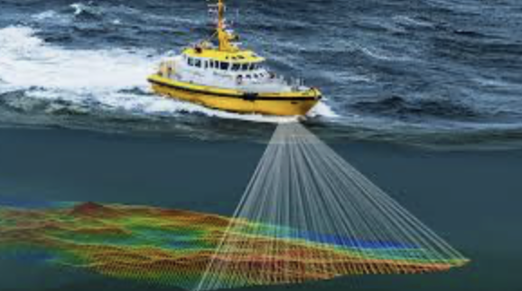
Bathymetric surveys are a critical component of hydrographic science, used to map and measure the depth and morphology of underwater environments. These surveys collect data on the shape, features, and elevation of the seafloor, enabling the creation of high-resolution 2D maps and 3D models of lakes, rivers, oceans, and other submerged terrains.
By using sonar technology—such as single-beam and multi-beam echo sounders—surveyors transmit sound pulses downward into the water column. These acoustic signals bounce off the bottom surface and return to the receiver, allowing the system to calculate water depths based on the time delay. With the integration of GPS positioning, motion sensors, and inertial navigation systems, the collected data is georeferenced and rendered into accurate bathymetric charts.
Whether for engineering, environmental, or navigational purposes, bathymetric surveys serve as the foundation for safe and informed underwater operations.
Applications of Bathymetric Surveys
Bathymetric data plays a vital role in a wide range of industries and public sector activities, including:
🌊 Environmental Monitoring and Research
Bathymetric surveys are essential in marine science, supporting:
-
Habitat mapping and marine biodiversity studies
-
Sediment transport analysis and shoreline erosion forecasting
-
Pollution tracking and environmental impact assessments
-
Monitoring climate change impacts on aquatic environments
🚢 Navigation and Maritime Safety
For ports, harbors, and coastal management authorities, bathymetric surveys provide:
-
Nautical chart updates for safe vessel passage
-
Identification of shoals, submerged rocks, and wrecks
-
Real-time support for dredging operations and depth maintenance
-
Baseline measurements for tidal predictions and current modeling
🏗️ Marine Construction & Engineering
Before any in-water infrastructure can be built, accurate seafloor information is essential:
-
Pre-construction site assessments for bridges, piers, breakwaters, and offshore wind farms
-
Substrate evaluation for submarine pipelines, tunnels, and cables
-
As-built surveys to verify underwater construction tolerances
-
Support for marine geotechnical sampling and engineering design
⚠️ Disaster Response & Incident Recovery
After natural or industrial events such as floods, tsunamis, or oil spills, bathymetric data supports:
-
Rapid mapping of submerged debris and hazards
-
Assessment of scour, washouts, and structural collapse
-
Restoration planning and progress tracking
Techniques and Technologies Used
Modern bathymetric surveys have evolved significantly with the adoption of advanced instrumentation and digital mapping tools. Common methods include:
-
Single-Beam Echo Sounders (SBES): Ideal for narrow water bodies or simple depth profiling. They record depth directly beneath the vessel in a single line.
-
Multi-Beam Echo Sounders (MBES): Provide wide swaths of data and high-resolution, 3D terrain mapping. Used in ports, rivers, and offshore.
-
Side-Scan Sonar: Captures sonar images of the seafloor texture, debris, and submerged objects, complementing bathymetric data.
-
Sub-bottom Profilers: Penetrate sediment layers to reveal subsurface geological structures.
-
USVs and ROVs: Unmanned systems are increasingly used for bathymetric data collection in hazardous or inaccessible locations.
-
RTK GPS and GNSS: Real-time geolocation ensures all depth data is accurately positioned in global or local coordinate systems.
Data is typically processed using specialized hydrographic software to generate contour plots, digital elevation models (DEMs), cross-sections, and geospatial databases compatible with CAD, GIS, and BIM platforms.
Benefits of Bathymetric Surveys
The value of bathymetric surveying lies in its precision, versatility, and ability to support diverse decision-making processes across sectors. Key advantages include:
✅ Accurate Mapping
-
Offers centimeter-level precision when paired with real-time kinematic GPS
-
Generates high-resolution seafloor models for planning and monitoring
✅ Enhanced Safety
-
Minimizes risks in marine construction and navigation by identifying hazards before work begins or vessels traverse the area
✅ Environmental Protection
-
Helps regulators and environmental consultants understand aquatic ecosystems and detect changes over time
✅ Operational Efficiency
-
Enables better planning for dredging, anchoring, mooring, and underwater installations
-
Reduces costs by avoiding surprises during construction or marine operations
✅ Regulatory Compliance
-
Meets the data requirements of environmental permits, impact assessments, and marine spatial planning (MSP) mandates
Summary
Bathymetric surveys are more than just depth measurements—they provide a window into the unseen underwater world. At Ven-Tech Subsea, our survey teams use the latest sonar systems and robotic technologies to deliver precise, actionable bathymetric data across a wide range of industries, including environmental consulting, infrastructure development, port operations, and offshore energy.
Whether you’re planning a marine construction project, updating nautical charts, or monitoring ecosystem changes, bathymetric surveys form the bedrock of sound, science-backed decision-making.
Let us help you map the unknown. Contact us today to schedule a professional bathymetric survey tailored to your project needs.
At Ven-Tech Subsea, we specialize in bathymetric surveys, leveraging cutting-edge technology to deliver accurate and reliable data for various marine applications. Our team of experts is committed to providing high-quality services tailored to meet the specific needs of our clients.
For more information on bathymetric surveys and their applications, check out this comprehensive guide from Marine Insight.
By understanding the importance and techniques of bathymetric surveys, you can better appreciate the complexities of marine environments and the role these surveys play in ensuring safety, environmental protection, and successful project execution. For professional bathymetric survey services, contact us today!