Ven-Tech Subsea Inspections – The West Coast’s Leading 3D Underwater Mapping Provider
At Ven-Tech Subsea Inspections, we are redefining underwater inspections, infrastructure assessments, and marine asset monitoring with 3D Underwater Mapping. As the leading provider of high-resolution 3D subsea mapping on the West Coast of Canada, we deliver exceptional accuracy, cost efficiency, and risk reduction for industries including marine construction, oil and gas, municipal water systems, and environmental monitoring.
Utilizing state-of-the-art ROV-mounted photogrammetry and sonar technology, our mapping services provide highly detailed, georeferenced digital models of submerged assets, allowing engineers, operators, and asset managers to analyze, measure, and monitor underwater structures with unparalleled precision.
What is 3D Underwater Mapping?
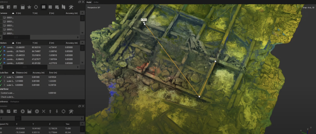
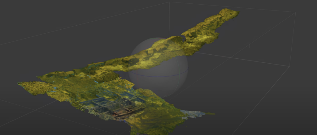
3D Underwater Mapping is a cutting-edge technique that combines high-resolution imaging, sonar data, and advanced digital modeling to create a real-world, scalable representation of submerged structures and seabeds. Using ROV-mounted cameras and multibeam sonar, we capture thousands of high-resolution images that are processed with specialized software to generate accurate, measurable models.
Key Benefits of 3D Underwater Mapping:
✔ High-Resolution Digital Twin Creation – Generate ultra-precise 3D models of underwater assets.
✔ Georeferenced Data for Accuracy – Ensures precise spatial positioning for engineering and maintenance.
✔ Non-Intrusive & Non-Destructive – Conducts inspections without physical contact, minimizing risk.
✔ Remote Analysis & Data Access – View, measure, and analyze data from anywhere.
✔ Historical Record & Change Monitoring – Track structural changes over time for predictive maintenance.
✔ Reduces Cost & Dive Team Risks – Eliminates the need for unnecessary diver interventions.
Applications of 3D Underwater Mapping
Our 3D underwater mapping technology is utilized across multiple industries, providing critical data for structural integrity assessments, environmental monitoring, and regulatory compliance.
➤ Marine & Offshore Infrastructure Mapping
• Bridge Piers & Foundations – Monitor underwater support structures for cracks, corrosion, and damage.
• Harbor & Port Facilities – Inspect bulkheads, docks, pilings, and mooring systems.
• Offshore Wind Turbines & Subsea Structures – Assess marine growth, erosion, and foundation integrity.
➤ Municipal & Potable Water Infrastructure (AWWA C652-19 Compliant)
• Reservoir & Water Tank Inspections – Fully compliant mapping of potable water systems without drainage.
• Intake & Outfall Mapping – Identify blockages, sediment accumulation, and pipeline integrity.
• Wastewater & Stormwater System Surveys – Detect leaks, cracks, and structural weaknesses.
➤ Oil & Gas Asset Mapping
• Subsea Pipeline Integrity Surveys – Identify corrosion, leaks, and stress fractures.
• FPSOs & Offshore Drilling Platforms – Conduct high-precision mapping for maintenance planning.
• Wellhead & Riser Inspections – Improve operational safety and regulatory compliance.
➤ Environmental & Seafloor Mapping
• Seafloor Topography Studies – Capture underwater terrain data for research and construction planning.
• Coral Reef & Marine Habitat Monitoring – Document marine ecosystems and habitat changes.
• Aquaculture & Fish Farm Infrastructure – Inspect mooring systems, cages, and nets.
How Our 3D Underwater Mapping Process Works
At Ven-Tech Subsea Inspections, we utilize a structured 4-step methodology to deliver high-precision, data-driven results.
1️⃣ Site Assessment & Planning
• Define project scope and mapping objectives.
• Optimize conditions for imaging and sonar capture.
2️⃣ ROV Deployment & High-Resolution Data Capture
• Use Deep Trekker Revolution ROVs with 4K UHD cameras & multibeam sonar.
• Capture thousands of georeferenced images for full-coverage 3D modeling.
3️⃣ Advanced Data Processing & 3D Model Generation
• Utilize industry-leading photogrammetry & LiDAR software.
• Generate detailed point clouds, textured meshes, and CAD-compatible outputs.
4️⃣ Comprehensive Analysis & Reporting
• Deliver interactive 3D models with precise measurement tools.
• Provide full engineering-ready reports for predictive maintenance.
Why Choose Ven-Tech Subsea Inspections for 3D Underwater Mapping?
✔ The West Coast’s Leading 3D Underwater Mapping Provider
Ven-Tech Subsea Inspections is the first and only company in Western Canada offering high-resolution ROV-based underwater mapping services.
✔ Industry-Leading ROV Technology
Our fleet of Deep Trekker Revolution ROVs is equipped with 4K UHD cameras, laser scanning, and multibeam sonar, ensuring unmatched accuracy and detail.
✔ Compliance with Regulatory Standards
• AWWA C652-19 Certified for Potable Water Reservoirs
• CSA & WorkSafe BC Compliant
• ISNetworld, Avetta, Cognibox, & Alcumus SafeContractor Certified
• $5 Million Contractors Liability Insurance
✔ Unmatched Safety & Efficiency
• Eliminates human risk in hazardous underwater environments.
• Provides real-time remote access & cloud-based reporting.
• Reduces the need for costly manual inspections and downtime.
Schedule a 3D Underwater Mapping Consultation Today
At Ven-Tech Subsea Inspections, we are committed to delivering industry-leading 3D underwater mapping solutions that improve asset management, safety, and operational efficiency.
Call Us Today: 604-230-3022
Email: info@ven-techsubsea.ca
Website: https://ventech.slyfoxdev.com/
Unlock the Future of Underwater Asset Management. Experience the power of precision 3D underwater mapping with Ven-Tech Subsea Inspections!